


| R A Cooke Track Layout Diagrams Posted by grahame at 16:02, 8th December 2025 |     |
"Track Layout Diagrams of the GWR and BR (WR) – Section 65 Chester -Wrexham by R.A. Cooke" - said to cover most of the GWR and BR (W) area - there seem to be about 60 publish with perhaps a further 9 to come.
Has anyone got either a list of all the sections - and/or a source of them and/or a copy of the one that includes Melksham? Anyone up on how they are copyrightwise?
| Re: R A Cooke Track Layout Diagrams Posted by Oxonhutch at 17:17, 8th December 2025 | |
"Track Layout Diagrams of the GWR and BR (WR) – Section 65 Chester -Wrexham by R.A. Cooke"
Don't have the above - but this is available on the Signalling Record Society website. What do you need it for?
| Re: R A Cooke Track Layout Diagrams Posted by grahame at 18:19, 8th December 2025 | |
"Track Layout Diagrams of the GWR and BR (WR) – Section 65 Chester -Wrexham by R.A. Cooke"
Don't have the above - but this is available on the Signalling Record Society website. What do you need it for?
Lisa is putting together a history exhibit for display in the museum cabinets at some point in the new year - looking at availability, sources, copyrights, etc ...
| Re: R A Cooke Track Layout Diagrams Posted by Oxonhutch at 19:30, 8th December 2025 | |
Maybe contact the S-R-S and see if they are happy to supply you free of charge a high definition file. It is a not-for-profit civic project that Lisa has in mind and, it gives them good publicity.
| Re: R A Cooke Track Layout Diagrams Posted by bradshaw at 19:54, 8th December 2025 | |
Section 21 of Cooke’s survey covers Wiltshire. Melksham p23 and 24
I have attached copies of Melksham.
Let me know if you need anything else
Lightmoor Press are bringing them all out, so must have the copyright if you need to ask permission. My copy is one of the early ring bound volumes.
https://lightmoor.co.uk/category.php?section=Track%20Plans
Rail 274/173 is an 1877 survey of the line from Thingley Jct to Sparkford. 174 covers Sparkfort to Weymouth
https://discovery.nationalarchives.gov.uk/details/r/C2359954
| Re: R A Cooke Track Layout Diagrams Posted by grahame at 08:24, 9th December 2025 | |
Maybe contact the S-R-S and see if they are happy to supply you free of charge a high definition file. It is a not-for-profit civic project that Lisa has in mind and, it gives them good publicity.
Section 21 of Cooke’s survey covers Wiltshire. Melksham p23 and 24
I have attached copies of Melksham.
Let me know if you need anything else ... [snip]
I have attached copies of Melksham.
Let me know if you need anything else ... [snip]
Thank you ... and thank you ... passing those on to Lisa and will come back in due course with a follow up / outcome. Please do not expect that follow up with the lightning speed of your answers on the forum - it's quiet a project she's putting together!
| Re: R A Cooke Track Layout Diagrams Posted by bradshaw at 09:10, 9th December 2025 | |
The Wilts Record Office at Chippenham has the plans and book of reference for the WSWR dated 1844/5. The map is in the form of a strip numbering every property through which it passes and 100yds on either side.
The book of reference lists each if these properties and give the owner, occupier and lessee for each. These are very under utilised resources. They can also be tied in to the Tithe Maps of similar dates. Copies were sent to every county through which the line was planned to pass.
The reference for this record office is
A1/371/68MS
| Re: R A Cooke Track Layout Diagrams Posted by bradshaw at 13:10, 9th December 2025 | |
I have found a tracing I did from the GWR route surveys. It is dated 1877. It shows the goods shed and platforms but no signal box. This was 3years after the gauge was narrowed. Somewhere there is a photo of Melksham supposedly from the 1874 gauge change.
| Re: R A Cooke Track Layout Diagrams Posted by grahame at 13:46, 9th December 2025 | |
I have found a tracing I did from the GWR route surveys. It is dated 1877. It shows the goods shed and platforms but no signal box. This was 3years after the gauge was narrowed. Somewhere there is a photo of Melksham supposedly from the 1874 gauge change.
Fascinating - and this is the 1874 picture:
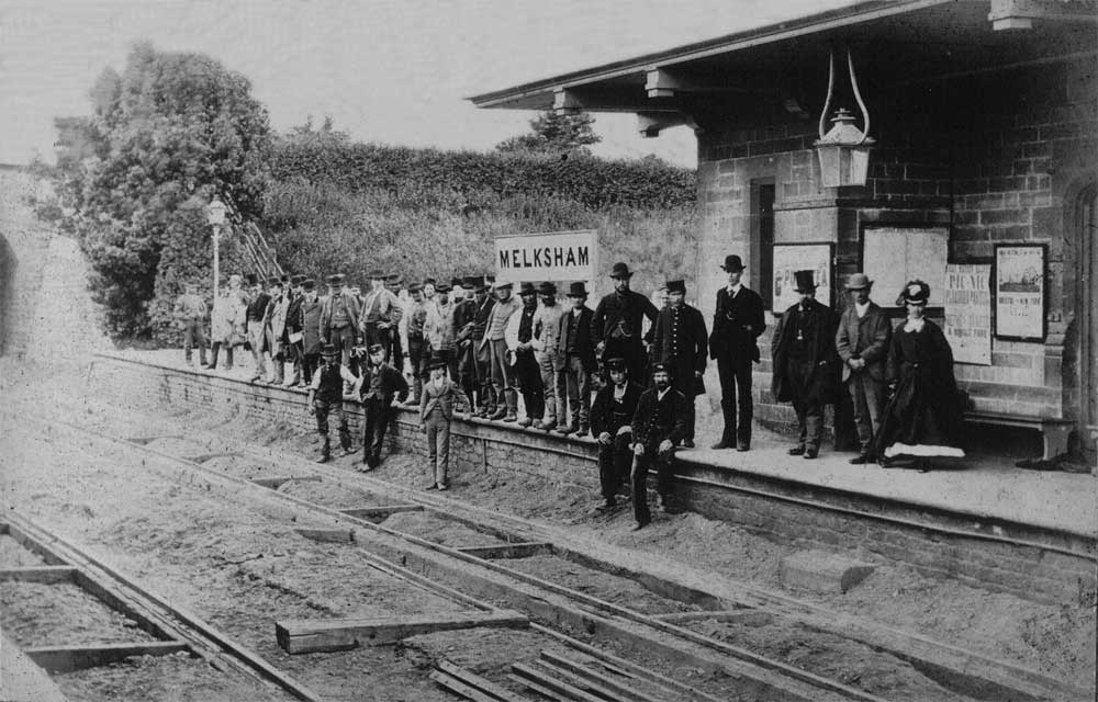
Supplied by the Melksham Historical Association for appropriate use to promote the (re)use of the station.
